The Alabama Department of Transportation (ALDOT) is leveraging cutting-edge drone technology to enhance safety, streamline operations, and ensure the efficient use of taxpayer dollars.
With its Unmanned Aerial Systems (UAS) program, ALDOT has gained a powerful tool to monitor construction projects and gather critical data from a bird’s-eye view.
“We are proud to utilize this innovative technology to help oversee and track the progress of our construction sites for the agencies’ decision makers,” said UAS Manager Michael Kyser. “Our team captures invaluable information through photos as well as videos collected by our drones.”
Daily Flights Across Alabama
Weather permitting, ALDOT’s UAS crews are flying drones on daily missions across the state, reaching altitudes that provide perspectives unavailable from the ground.
The drones are deployed for various purposes, including preconstruction and post construction flights, as well as flights throughout the duration of the construction project.
“Our standard timetable for updates is about every six weeks,” Kyser explained. “However, we’re flexible. Some projects are flown monthly, weekly, or even daily, depending on the needs of agency personnel.”
More Than Just Photos
ALDOT’s drones go far beyond capturing aerial images. Each photo has data points that can be transformed into 3D models and/or orthomosaic maps using advanced processing software.
“What may look like an ordinary photo to most people is actually a treasure trove of information,” Kyser said. “These data points can also be extracted almost instantly to support various teams and projects.”
This capability allows ALDOT to detect potential issues, monitor progress, and ensure accuracy in ways that traditional methods might miss. The data also enables immediate sharing with project leaders, saving time and reducing costs.
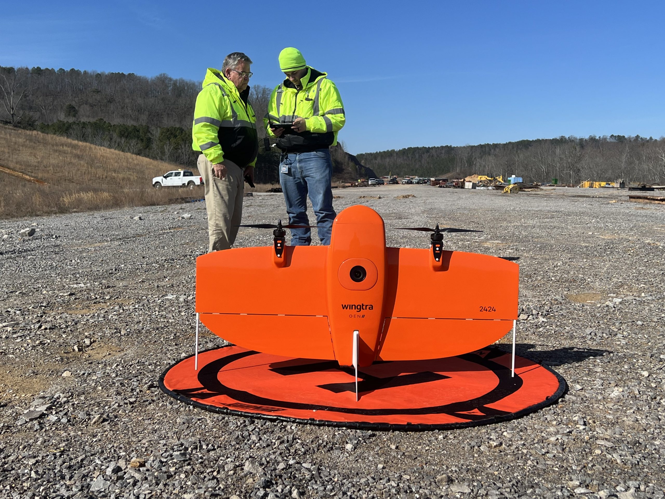
A Fleet Built for Purpose
ALDOT operates a diverse fleet of drones tailored to specific tasks. The largest, the Wingtra, is a fixed-wing drone capable of flying up to the legal altitude of 400 feet high at speeds of 30 miles per hour. Equipped with a 61-megapixel camera, it’s ideal for large-scale projects that requires detailed imagery like long corridors such as the West Alabama Highway and the Northern Beltline.
“Our Wingtra is the only fixed-wing drone we currently have,” Kyser said. “It’s great for big projects, but about 90% of our work is done with our DJI Mavic drones.”
The Mavic drones, smaller and more versatile, handle the majority of ALDOT’s aerial operations. In addition, the Skydio drones can be used to create 3D models of structures or assist bridge inspectors when requested.
Looking Ahead
As ALDOT continues to expand its drone program, the department remains committed to using this technology. The drones will continue to improve safety, reduce costs, and deliver high-quality imagery and data for infrastructure and construction projects. The innovative use of drones underscores ALDOT’s dedication to staying at the forefront of transportation technology.
UAS Team: J.D. D’Arville, Mike Kyser, Jonathan Woodham, Aaron Lyons, Kyle Clifford, Steve Brantley, Alex Limbaugh and Diana Ridley.